


More Applications
Provide high-quality solutions and services for more industry users and partners
The Radio and Television Network Resource Sharing Service Platform is a comprehensive platform for radio and television network resource management developed based on GIS technology. On the basis of spatially maintaining and displaying communication network resource data, it supports the configuration and maintenance of customer business line information, provides grid refinement management tools, and provides strong support for daily work such as planning and design, external construction, line configuration, emergency repair, equipment line inspection, etc., effectively solving the difficulties of resource line maintenance and complex management. At the same time, through in-depth mining and analysis of resource data, information support is provided for front-end business and marketing analysis, and core data support is provided for enterprise information operation.
GIS-based Radio and Television Network Resource Management System


Radio and Television Resource Management System Enhancement
Basic Data Maintenance Function


Visual maintenance and display of radio and television network resource entity data and connection logic relationships on the map, mainly including the following functions: entity equipment entry and attribute maintenance, photo management, comprehensive query, cable route laying, cable equipment termination, optical cable splicing, terminal panel management of交接设备, data logic checking and error correction.
Types of managed resource data:
●Public resources: regions, sub-regions, branches, sub-branches, communities, equipment rooms, GIS electronic maps, buildings;
●Pipeline management support network resources: manholes, pipelines, pipe holes, sub-holes, equipment rooms, lead-up points, poles, suspension wires, guy wires;
●Equipment room equipment resources: optical transmitters, OLTs, ODFs;
●Optical cable network resources: optical cables, optical cable segments, optical交接boxes, discs, optical workstations, EOC headends, optical splitters, OUNs;
●Coaxial cable network resources: coaxial cables, coaxial cable segments, signal amplifiers, branchers, distributors, cross-connectors;
Drawing Management
Starting from the actual needs of radio and television network planning, the system uses electronic maps as base maps and combines network resource data to automatically draw various types of data drawings. The entities and lines of the drawings can be displayed independently on a certain layer, and after drawing, they can be saved in the database. It also establishes corresponding relationships with data in the pipeline resource system, can annotate and display optical cable specifications, core numbers, lengths, occupancy situations, etc., and can be dynamically updated and printed.
Main drawing types: route maps (optical cables, coaxial cables, point equipment, designated areas), logic diagrams (optical cables, coaxial cables, point equipment, designated areas), optical cable fiber distribution diagrams, pipeline pole route diagrams, optical route diagrams.


Engineering Process Management
The system provides a complete solution for engineering construction process management, using software to manage all process links of engineering construction as a whole, providing engineering process approval, engineering progress monitoring, engineering design, engineering material statistics, engineering cost estimation and other functions.


●Engineering Process Customization
The system supports custom configuration of engineering processes, setting corresponding process nodes and processing positions, personnel, and time requirements;
●Overall Engineering Process Management
Supports full-process tracking management of project initiation, project approval, design and construction, and project completion and storage;
●Planning and Design Management
Provides planning and design functions based on existing data, capable of automatically generating various engineering drawings;
●Material Statistics
Automatically statistics materials based on design plans and connects with financial analysis;
●Completion Management
After project acceptance and completion, the planning and design data can be directly stored without secondary entry.
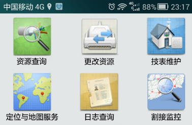
Mobile Application
"Love Resources" is developed using the open MapGIS cloud GIS mobile platform through service assembly, enabling users to directly use mobile devices such as phones to query, maintain, manage, and communicate resources without time and location restrictions - a new generation of mobile resource management systems.

●Resource Query: Provides comprehensive query of the entire network data of the radio and television network resource management system, supporting new query interaction modes such as QR code scanning, barcode scanning, and shake search for nearby resources.
●Resource Modification: Provides real-time online modification of radio and television network resource data;
●Technical Form Maintenance: Provides service support for equipment rectification and line inspection;
●Location and Map Services: Provides map and location services;
●Cutover Monitoring: Provides services for monitoring the progress of optical cable engineering cutover and交接设备engineering cutover, as well as business alarm monitoring caused by these activities;
●Emergency Repair Events: Provides services for external line emergency repair events including fault location, business impact analysis, route scheduling analysis, and emergency repair progress monitoring;
●Hazard Management: Provides full-process management of line equipment hazard entry, approval, plan formulation, external line implementation, and completion archiving;
Typical Cases
●Ningbo Huashu Radio and Television Network Resource Management System
●……
Related Software
Smart City
- Smart City Spatiotemporal Big Data Platform
- MapGIS Smart Thermal Solution
- Smart Emergency Command Platform
- MapGIS Field Work Order Solution
- Enterprise One Picture Solution
- Smart Security Combat Platform
- MapGIS Pipeline GIS Solution
- Smart Chemical Industrial Park Solution
- Smart Patrol and Prevention Platform
- MapGIS Integrated Management System Solution for Underground Municipal Facilitie
Natural Resources
- National Land Space Basic Information Platform: Smart Hub
- National Spatial Planning Implementation Monitoring Network (CSPON)
- Real estate convenience service system
- Realistic 3D Solution
- Natural Resource Asset Management Solution
- One code land management solution
- Ocean monitoring solutions
- Intelligent Disaster Management Solution
- Integrated solution for natural resources e-government
- Land survey solution
Smart Geology
- MapGIS Digital Twin Watershed Solution
- MapGIS Groundwater Informatization Solution
- MapGIS Iterative Geological Modeling Tool
- Geological Informationization Solution
- MapGIS Geological Data Management and Display System
- MapGIS Field Data Collection System
- MapGIS Smart Environmental Protection Solution
- Integrated solution for urban geology above ground and underground
- Geological big data cloud platform
- MapGIS Mining Management and Modeling System
More Applications
- Series solutions for the communication industry
- MapGIS CIM Underground Space Platform
- Smart wind power solution
- Solution for Radio and Television Resource Management
- Transportation Meteorological Support Service Solution
- High performance processing solution for remote sensing images
- Multi source remote sensing data management solution
- Solution for Multi source Meteorological Information Integration Application and Service Platform
- Solution for Visualization Platform of Meteorological 3D Storm Body Echo Data
- Solution for Weather Radar Construction Business Platform


