


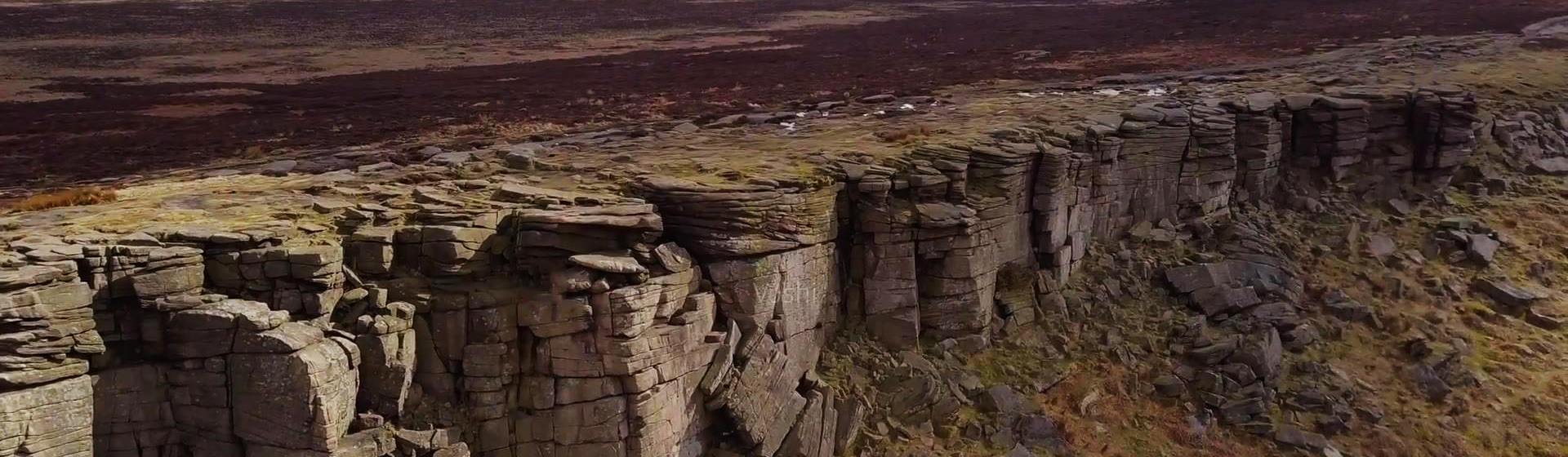
Smart Geology
Provide information services based on geological resource related data to achieve deep mining, sharing, and exchange of geological resource information.
The MapGIS Mine Management and Modeling System is a product developed by China National Land and Resources Corporation based on the "General Principles for Solid Mineral Exploration" (GB/T13908-2020) and the "Technical Requirements for 3D Geological Modeling of Solid Mineral Exploration" (DZT0383-2021). It integrates mine data management and modeling analysis for solid mineral resources using the MapGIS platform. With the powerful data management and modeling functions provided by the system, it can achieve 3D reconstruction, visualization expression, and 3D expression of attribute features of various geological bodies and geological structures. It can deeply analyze the spatial structure of geological bodies, provide 3D model data for mineral resource exploration, resource estimation, mineralization law research, mineralization prediction, mining and mine management work, and serve mineral resource exploration and development and mine management work.

ProductFunctions
The core goal of system function construction is to provide powerful three-dimensional modeling and analysis functions for mineral resources, expressing the spatial distribution characteristics and internal attribute information of geological structures in the modeling area in true 3D form. Its core functions include data management, exploration engineering and tunnel modeling, orebody modeling, stratum modeling, attribute modeling, integrated above-ground and underground display of mines, and model analysis.
Data Management
Unified database construction and management for multi-source heterogeneous data, seamlessly connected with mine modeling;
·Supports mineral resources reserve database standards and solid mineral 3D modeling database standards;
·Supports managing archived data in the form of mining area - mine - annual, consistent with the mineral resources reserve database management system issued by the former Ministry of Land and Resources, ensuring horizontal data exchangeability;
·Supports importing various data such as mining area boundaries, geological maps, topographic data, exploration lines, drill holes, profiles, and heterogeneous platform 3D models;
·Supports unified user permission management through the backend.
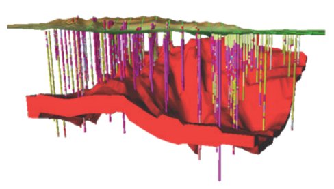
Orebody Modeling
Adopting cross-section geological modeling, based on cross-section data to construct orebody models, accurately depicting information such as orebody morphology, occurrence, volume, and spatial distribution with high precision, facilitating geologists to better understand spatial morphology, grade distribution, and other information.
·Supports setting intercalated rock parameters, with the system automatically removing intercalated rocks
·Supports providing complete orebody extrapolation and connection generation rules automatically constructing pinch-out blocks according to solid mineral geological exploration specifications
·Supports automatic construction of orebody models with the same orebody number based on cross-section data
Orebody Modeling Effect Diagram
Stratum Modeling
Fully utilize data obtained from exploration engineering to perform semi-automatic human-computer interactive modeling under constraints of surface topography, geological maps, fault lines, etc., expressing elements such as morphology, distribution, and contact relationships of geological objects including geological structures, strata, igneous rocks, alteration zones, and orebodies.
·Incorporate professional geological understanding during the modeling process
·Provide comprehensive 3D line, surface, and volume generation and editing tools
·Support multi-person collaborative modeling to shorten modeling cycles
Attribute Modeling
·Based on geological body attribute characteristics, use geological attribute data for spatial interpolation to construct 3D grid attribute models, reflecting attribute characteristics such as orebody lithology, grade, mineral content, alteration intensity, metallogenic geological conditions, orebody characteristics, geophysical and geochemical properties.
·High-precision grid discretization modeling constrained by geological structure framework models, quickly constructing attribute models while taking geological structures into account;
·Provide multiple interpolation algorithms such as inverse distance weighting, simple kriging, universal kriging, and fast interpolation;
·Grid discretization supports both conformable and regular grid discretization, enabling multi-precision and multi-scale division of models.

Orebody Grade Model Effect Diagram
Exploration Engineering and Tunnel Modeling
·Provide rapid construction functions for exploration engineering models such as orebody surface, exploration lines, and exploration holes, and tunnel models, realistically presenting spatial distribution of exploration engineering, tunnel orientation, affiliation relationships, and spatial position relationships in 3D scenes.
·Support rapid construction and visualization of various hole types including vertical and inclined holes;
·Support construction of various tunnel cross-sections including arch, rectangular, circular, and trapezoidal shapes;
·Support automatic connectivity processing of tunnel intersections, effectively solving the problem of unconnected intersection points.
Integrated Above-Ground and Underground Display of Mines
·Provide professional and practical full-space model fusion tools to achieve integrated above-ground and underground fusion display of mines, meeting full-space model visualization needs.
·Support multiple 3D model data exchange formats, compatible with MapGIS data formats of different versions, supporting 3D format model data such as .3ds, .obj, .dae, .osgb, .fbx, .xml, .x, .rvt
·Through coordinate transformation, data registration, fusion and other technologies, achieve seamless fusion of above-ground landscapes, oblique photography, exploration engineering, geological bodies, and terrain imagery
·Support lightweight processing of models during import to achieve fast loading and display of model data
Model Analysis
·Provide a complete and practical set of model analysis tools to help users more clearly understand internal and external morphology and stratum conditions of models, providing further assistance and reference for mining area geological research, mining area exploitation design,
·Resource replacement prospecting.
·Support drill hole query, profile query, stratified coloring, attribute value modification based on attributes or ranges, attribute filtering, and color table editing query analysis for attribute models
·Support interactive queries for structural models including sectioning, explosion, dynamic clipping, extraction of virtual holes, and point-line-surface structural parameters
Product Features
·Clear and understandable data organization structure, enabling users to quickly archive data;
·Rich modeling methods that can meet modeling and analysis needs for different objects in solid mineral exploration;
·Able to achieve refined construction of 3D geological models for multi-level, multi-topic, and arbitrarily complex deposit types of mineral resources;
·Introduce a new algorithm based on BPLI for reconstructing 3D surfaces from 2D parallel contours, effectively improving computational efficiency of orebody 3D surface reconstruction;
·Establish a dynamic update mechanism for orebody models, enabling dynamic updates of orebody models based on data obtained during production processes;
·Integrated above-ground and underground display of mines, completely presenting 3D spatial information, laying technical foundations for integrated mine management and intelligent operation.
Application Cases
·Specialized modeling software for national crisis mine projects
·3D modeling project for large mineral deposits in Shandong Province透视project
·3D modeling software for mine projects in Jiangxi Province Geological Big Data Platform Project
·3D modeling technical services for geological bodies and orebodies in Hunan Province 3D spatial geological mineral reserve management system project
·Mineral resources planning management information system construction project in Gansu Province
·3D modeling system construction project for geological uranium mines in Guangdong Province
·Metal and non-metal mineral achievement integration survey project in Tongbai region, Henan Province
·Geological exploration information integration (survey) software project for gold mines in Xiaqinling region, Henan Province
·Solid mineral auxiliary exploration and 3D modeling system development project for Anhui Geological Survey Institute
·3D geoscience modeling system construction project for digital mines of Xinjiang Uygur Autonomous Region Geological and Mineral Exploration and Development Bureau
·Geological assurance system construction project for Yanzhou Coal Mining
·3D modeling project for Zhibo iron mine in Xinjiang
Related Software
Smart City
- Smart City Spatiotemporal Big Data Platform
- MapGIS Smart Thermal Solution
- Smart Emergency Command Platform
- MapGIS Field Work Order Solution
- Enterprise One Picture Solution
- Smart Security Combat Platform
- MapGIS Pipeline GIS Solution
- Smart Chemical Industrial Park Solution
- Smart Patrol and Prevention Platform
- MapGIS Integrated Management System Solution for Underground Municipal Facilitie
Natural Resources
- National Land Space Basic Information Platform: Smart Hub
- National Spatial Planning Implementation Monitoring Network (CSPON)
- Real estate convenience service system
- Realistic 3D Solution
- Natural Resource Asset Management Solution
- One code land management solution
- Ocean monitoring solutions
- Intelligent Disaster Management Solution
- Integrated solution for natural resources e-government
- Land survey solution
Smart Geology
- MapGIS Digital Twin Watershed Solution
- MapGIS Groundwater Informatization Solution
- MapGIS Iterative Geological Modeling Tool
- Geological Informationization Solution
- MapGIS Geological Data Management and Display System
- MapGIS Field Data Collection System
- MapGIS Smart Environmental Protection Solution
- Integrated solution for urban geology above ground and underground
- Geological big data cloud platform
- MapGIS Mining Management and Modeling System
More Applications
- Series solutions for the communication industry
- MapGIS CIM Underground Space Platform
- Smart wind power solution
- Solution for Radio and Television Resource Management
- Transportation Meteorological Support Service Solution
- High performance processing solution for remote sensing images
- Multi source remote sensing data management solution
- Solution for Multi source Meteorological Information Integration Application and Service Platform
- Solution for Visualization Platform of Meteorological 3D Storm Body Echo Data
- Solution for Weather Radar Construction Business Platform


