


Smart Geology
Provide information services based on geological resource related data to achieve deep mining, sharing, and exchange of geological resource information.
The underground water information solution is supported by the MapGIS platform, which integrates the storage and management of monitoring data, hydrogeology, related business management and other types of data, explores the deep value of data, supports the output of 2D and 3D thematic results, vividly displays the occurrence state of underground water under natural geological conditions, creates multiple underground water thematic information application scenarios, and provides data support for underground water development and utilization, underground water ecological protection, engineering construction impact assessment, etc.

ConstructionContent
· Data Center
Data Aggregation
Real-time monitoring of groundwater level, flow, water quality and other change information, real-time access to the data center for storage management and visual analysis.

2D Mapping
Supports the creation of various groundwater thematic maps, can generate maps with one click based on customized templates and supports map editing.
3D Modeling
· Modeling Methods
Provide multiple modeling methods to construct groundwater entity models, visualize groundwater and its hosting media in 3D, effectively support hydrogeologists' understanding of groundwater movement patterns, and provide decision support for rational groundwater exploitation and geological environmental protection during the exploitation process.
· Model Integration
Adopt unified physical storage, logical organization, spatiotemporal identification and unified coordinate reference, use coordinate transformation, control point registration, Boolean operations, spatial correction and other methods to achieve integrated fusion of full-space data such as landscape, BIM, oblique photography, pipelines, geological bodies, and remote sensing images.
Visualization Display
· Visualization Rendering
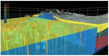
Based on M3D technology to render high-fidelity 3D groundwater distribution scenes, quickly and efficiently achieve high-quality simulation and restoration of large-scale groundwater scenes, vividly displaying the natural occurrence state of groundwater under natural geological conditions.

Large Scene High-Fidelity Visualization Rendering
· Full-Space Display
Supports integrated display of full-space above and below ground for basic geographic geology, groundwater, underground pipelines, underground structures and other data, providing a visualization foundation for analyzing the relationship between groundwater distribution and natural geological conditions and social factors.
· Application Scenarios
Groundwater Development and Utilization
By extracting aquifer information from geological structure models, constructing 3D models of water sources, evaluating monitoring indicators of different dimensional spaces and different media of water sources to achieve deep water finding, reserve estimation and groundwater quality analysis and evaluation, statistics available underground water resources, providing data foundation for groundwater resources development and utilization, reasonably planning the proportion of domestic water, industrial water and other water usage, ensuring dynamic balance between recharge and consumption, and realizing sustainable development using groundwater recoverability.
Groundwater Ecological Protection
By accessing real-time groundwater monitoring data and displaying and statistically analyzing it, establish one-to-one or one-to-many monitoring well and water level/water quality monitoring relationships, grasp groundwater change patterns and exploitation situations, statistics pollution indicator related data, highlight areas where pollution indicators exceed standards, trace back pollution sources according to pollutant diffusion trends, achieve effective distinction and identification of natural and anthropogenic pollution behaviors, and provide visualization support for precise groundwater pollution control.

Pollution Source Tracing
Engineering Construction Impact Assessment
Integrate professional numerical simulation results of groundwater, display underground water flow fields and groundwater quality migration through 4D visualization, and grasp groundwater dynamic information in real time.
Combined with the impact of specific groundwater elements on engineering construction in water quality analysis and evaluation, such as PH value's corrosivity to underground buildings, warn of adverse geological factors, and provide reasonable engineering construction suggestions to assist engineering site selection.
Advantages and Features
Domestic GIS Platform:Has a completely independent and controllable GIS kernel, supports various domestic chips, operating systems, servers, domestic databases, etc., and guarantees the security of geographic spatial information from basic software and hardware environments.
Technological Innovation:MapGIS has always practiced an independent innovation development route, groundwater-related technical methods are increasingly mature, and achieved a technical breakthrough in the integrated display of numerical simulation models and geological models.
Rich Experience:MapGIS has undertaken numerous provincial, municipal, and site-level groundwater informatization construction projects, accumulated rich practical experience, continuously improved technically, and continuously expanded business-wise.
Project Cases

Related Software
Smart City
- Smart City Spatiotemporal Big Data Platform
- MapGIS Smart Thermal Solution
- Smart Emergency Command Platform
- MapGIS Field Work Order Solution
- Enterprise One Picture Solution
- Smart Security Combat Platform
- MapGIS Pipeline GIS Solution
- Smart Chemical Industrial Park Solution
- Smart Patrol and Prevention Platform
- MapGIS Integrated Management System Solution for Underground Municipal Facilitie
Natural Resources
- National Land Space Basic Information Platform: Smart Hub
- National Spatial Planning Implementation Monitoring Network (CSPON)
- Real estate convenience service system
- Realistic 3D Solution
- Natural Resource Asset Management Solution
- One code land management solution
- Ocean monitoring solutions
- Intelligent Disaster Management Solution
- Integrated solution for natural resources e-government
- Land survey solution
Smart Geology
- MapGIS Digital Twin Watershed Solution
- MapGIS Groundwater Informatization Solution
- MapGIS Iterative Geological Modeling Tool
- Geological Informationization Solution
- MapGIS Geological Data Management and Display System
- MapGIS Field Data Collection System
- MapGIS Smart Environmental Protection Solution
- Integrated solution for urban geology above ground and underground
- Geological big data cloud platform
- MapGIS Mining Management and Modeling System
More Applications
- Series solutions for the communication industry
- MapGIS CIM Underground Space Platform
- Smart wind power solution
- Solution for Radio and Television Resource Management
- Transportation Meteorological Support Service Solution
- High performance processing solution for remote sensing images
- Multi source remote sensing data management solution
- Solution for Multi source Meteorological Information Integration Application and Service Platform
- Solution for Visualization Platform of Meteorological 3D Storm Body Echo Data
- Solution for Weather Radar Construction Business Platform


